
Cyclone Tracker: Live Tropical Cyclone Map and Path
Updated · 19 Nov 2026
2 cyclones are active right now: Tropical Cyclone Xavier (South Pacific) and Tropical Cyclone Akvan (North Indian Ocean). The strongest, Tropical Cyclone Xavier, has 1-minute winds of 105 kt (120 mph, 195 km/h) by JTWC, 436 nm east-northeast of Manua Islands (06:00 UTC).
Cyclone status by region
JTWC warnings, checked every 15 minutes. Last check 16:13 UTC. Official warnings come from the centre named for each region below.
- North Indian Ocean: 1 active storm (Tropical Cyclone Akvan)season no fixed season; two peaks, April to June and October to December · strongest now 35 kt (40 mph, 65 km/h)ACTIVE
- South-West Indian Ocean: no active stormseason 15 November to 30 April · in season, 163 days left · last storm: Three, 7 Nov to 8 Nov 2026, peak 35 kt (40 mph, 65 km/h) (JTWC warnings)QUIET
- Australian region: no active stormseason 1 November to 30 April · in season, 163 days left · latest storm we can confirm: Severe Tropical Cyclone Narelle, 27 Mar 2026, severe tropical cyclone (AAP via The New Daily, 28 Mar 2026)QUIET
- South Pacific: 1 active storm (Tropical Cyclone Xavier)season 1 November to 30 April · in season, 163 days left · strongest now 105 kt (120 mph, 195 km/h)ACTIVE
Cyclone map: Indian Ocean, Australia and the South Pacific
Active cyclones now
- Tropical Cyclone Xavier (04P): 105 kt (120 mph, 195 km/h)436 nm east-northeast of Manua Islands · moving southeast at 4 kt · 953 hPa · position 06:00 UTC 19 Nov (10h ago) · warning 09 · JTWC105 KT
- Tropical Cyclone Akvan (05B): 35 kt (40 mph, 65 km/h)433 nm south-southwest of Kolkata, India · moving north-northwest at 8 kt · 1002 hPa · position 12:00 UTC 19 Nov (4h ago) · warning 12 · JTWC35 KT
MONITORWORLD APP · iOS + ANDROID
Get an alert before the cyclone arrives
MonitorWorld sends a push alert when a cyclone forms or strengthens near the places you follow, with the official source and the forecast track.
- Storms, quakes and wildfires on one map
- Alerts for home, family and travel spots
- Free, no account needed


 On a computer? Scan with your phone camera.

Recent cyclones
- Tropical Cyclone ThreeSouth-West Indian Ocean · 7 Nov to 8 Nov 2026 · peak 35 kt (40 mph, 65 km/h) (JTWC 1-min) · MonitorWorld archive of JTWC warnings35 KT
- Tropical Cyclone MurasuNorth Indian Ocean · 1 Nov to 3 Nov 2026 · peak 85 kt (100 mph, 155 km/h) (JTWC 1-min) · MonitorWorld archive of JTWC warnings85 KT
- Cyclone Arnab: crossed the Andhra Pradesh coast near Yanam and Narsapur early on 28 October (India time) with winds of 125-135 km/h, gusting to 150 km/h; 3 deaths reported by the Andhra Pradesh State Emergency Operations Centre, 28 Oct 202628 Oct 2026 · very severe cyclonic storm at landfall (IMD) · reported by IMD via The Watchers; Outlook IndiaN INDIAN OCEAN
- Moderate Tropical Storm Agueda: formed near the Seychelles, the first storm of the 2026-27 season and more than three weeks earlier than the median date; Meteo-France expected no threat to Madagascar, Mayotte or La Reunionformed 20 Oct 2026 · moderate tropical storm · reported by Meteo-France via Mayotte HebdoSW INDIAN OCEAN
- Tropical Cyclone Wati: brought Fiji Met warnings and minor damage to the southern Cook Islands (Aitutaki)18-19 Oct 2026 · tropical cyclone · reported by PINA, 19 Oct 2026SOUTH PACIFIC
- Severe Tropical Cyclone Narelle: hit the Western Australia coast near Exmouth and Coral Bay, tearing off roofs and damaging several towns27 Mar 2026 · severe tropical cyclone · reported by AAP via The New Daily, 28 Mar 2026AUSTRALIA
- Cyclone Gezani: made landfall at Toamasina, Madagascar; 59 deaths reported by Madagascar's disaster office (BNGRC), 16 Feb 202610 Feb 2026 · tropical cyclone · reported by Reuters via TimesLIVESW INDIAN OCEAN
Key context
Forecast track: Tropical Cyclone Xavier (JTWC warning 09, 09:00 UTC 19 Nov)
Joint Typhoon Warning Center forecasts weakening to 35 kt by 24 Nov. Times are UTC; winds are 1-minute sustained winds unless noted. Read the official text and the official forecast graphic before you make any decision.
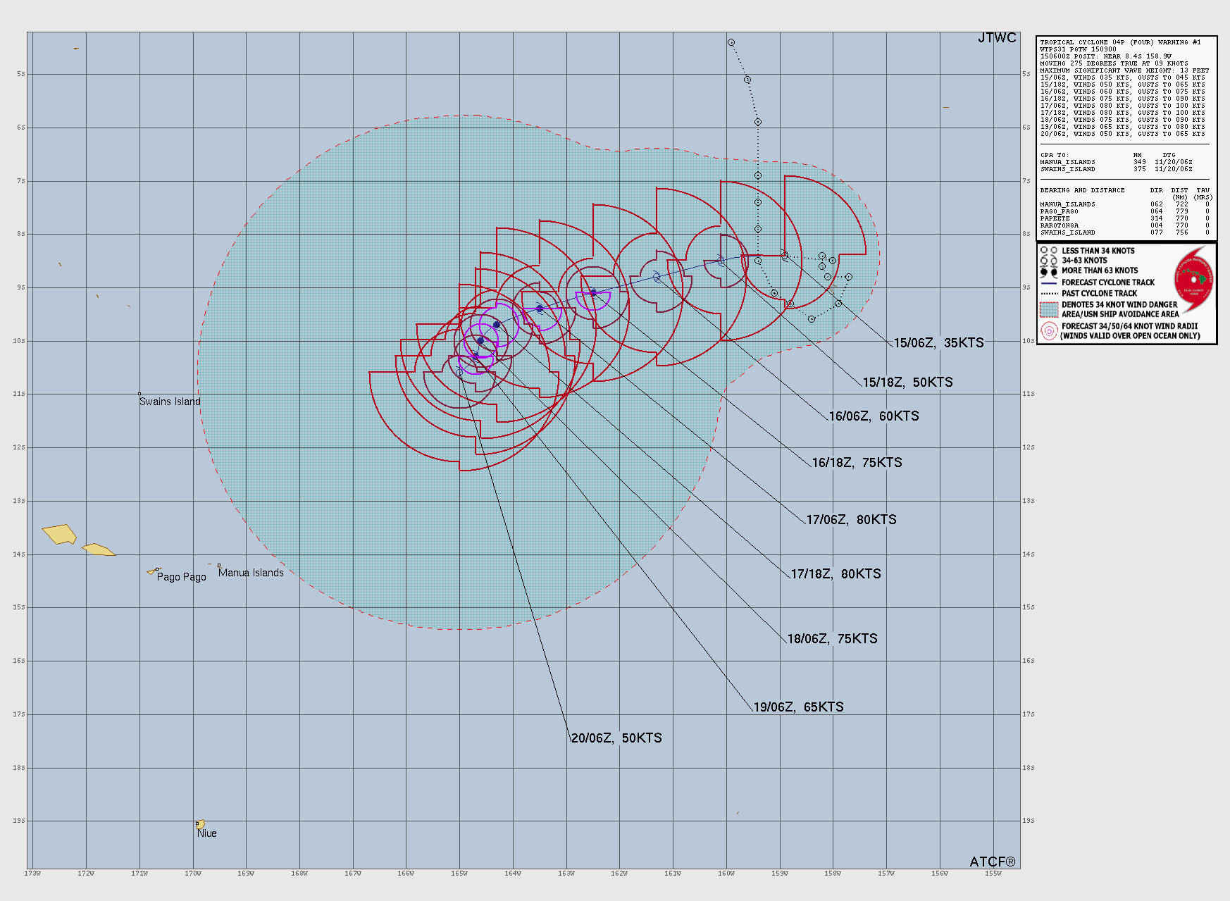
| Time (UTC) | Position | Max wind | Strength |
|---|---|---|---|
| Now: 19 Nov 06:00 | 10.6°S 163.2°W | 105 kt (120 mph) | hurricane strength |
| 19 Nov 18:00 | 10.9°S 163.0°W | 100 kt (115 mph) | hurricane strength |
| 20 Nov 06:00 | 11.2°S 163.0°W | 90 kt (105 mph) | hurricane strength |
| 20 Nov 18:00 | 11.5°S 163.5°W | 75 kt (85 mph) | hurricane strength |
| 21 Nov 06:00 | 12.0°S 164.3°W | 60 kt (70 mph) | storm strength |
| 21 Nov 18:00 | 12.3°S 165.3°W | 50 kt (60 mph) | storm strength |
| 22 Nov 06:00 | 12.8°S 166.3°W | 45 kt (50 mph) | storm strength |
| 23 Nov 06:00 | 14.0°S 168.1°W | 40 kt (45 mph) | storm strength |
| 24 Nov 06:00 | 14.6°S 170.1°W | 35 kt (40 mph) | storm strength |
Forecast track: Tropical Cyclone Akvan (JTWC warning 12, 15:00 UTC 19 Nov)
Joint Typhoon Warning Center forecasts weakening to 20 kt by 21 Nov. Times are UTC; winds are 1-minute sustained winds unless noted. Read the official text and the official forecast graphic before you make any decision.

| Time (UTC) | Position | Max wind | Strength |
|---|---|---|---|
| Now: 19 Nov 12:00 | 16.0°N 85.3°E | 35 kt (40 mph) | storm strength |
| 20 Nov 00:00 | 17.9°N 85.0°E | 35 kt (40 mph) | storm strength |
| 20 Nov 12:00 | 19.7°N 84.9°E | 30 kt (35 mph) | depression |
| 21 Nov 00:00 | 21.5°N 85.2°E | 20 kt (25 mph) | depression |
Who warns where
| Region | Official centre | Season | Countries |
|---|---|---|---|
| North Indian Ocean (Bay of Bengal, Arabian Sea) | IMD, RSMC New Delhi | April to June and October to December | India, Bangladesh, Myanmar, Sri Lanka, Pakistan, Oman |
| South-West Indian Ocean | Meteo-France, RSMC La Reunion | 15 Nov to 30 Apr | Madagascar, Mozambique, Mauritius, La Reunion |
| Australian region (90°E to 160°E) | Bureau of Meteorology | 1 Nov to 30 Apr | Australia, Indonesia, Papua New Guinea |
| South Pacific (east of 160°E) | Fiji Met, RSMC Nadi | 1 Nov to 30 Apr | Fiji, Vanuatu, New Caledonia, Tonga, Samoa |
Cyclone strength scales
The same cyclone gets different labels in different places, because each centre averages the wind over a different time. This page shows JTWC's 1-minute winds in kt for every storm, so storms in all oceans compare directly.
| IMD class | Winds (kt) | Winds (km/h) |
|---|---|---|
| Depression | 17-27 | 31-49 |
| Deep depression | 28-33 | 50-61 |
| Cyclonic storm | 34-47 | 62-88 |
| Severe cyclonic storm | 48-63 | 89-117 |
| Very severe cyclonic storm | 64-89 | 118-166 |
| Extremely severe cyclonic storm | 90-119 | 167-221 |
| Super cyclonic storm | 120 or more | 222 or more |
Australian cyclone categories
The Bureau of Meteorology rates cyclones from Category 1 to 5 by the strongest gusts: Category 1 below 125 km/h, Category 2 125-164 km/h, Category 3 165-224 km/h, Category 4 225-279 km/h and Category 5 above 280 km/h. Categories 3 to 5 are "severe tropical cyclones". An Australian Category 3 is not the same as a Category 3 hurricane.
Hurricane, typhoon or cyclone: the same storm
All three are tropical cyclones: rotating storms that form over warm ocean water. Only the name changes with the ocean. Over the North Atlantic and the Northeast Pacific, a storm with sustained winds of 64 kt (74 mph) or more is a hurricane. Over the Northwest Pacific it is a typhoon. Over the Indian Ocean and the South Pacific it is a cyclone (in Australia, a tropical cyclone of any strength).
Official cyclone information
- India Meteorological Department: cyclone warnings for India and the North Indian Ocean.
- Bureau of Meteorology: Australian cyclone warnings and forecast track maps.
- Meteo-France La Reunion: South-West Indian Ocean cyclones.
- Fiji Meteorological Service and MetService New Zealand: South Pacific cyclones.
- Joint Typhoon Warning Center: the warnings used for the tracks on this page.
Questions and answers
Is there a cyclone right now?
When is cyclone season in India?
When is cyclone season in Australia?
Why does IMD or BoM give a different strength?
Who names cyclones?
What is the difference between a cyclone, a hurricane and a typhoon?
Related live pages
- /live/hurricane-trackerHurricane trackerActive hurricanes and tropical storms with the NHC cone and track.
- /live/typhoon-trackerTyphoon trackerWest Pacific typhoons: path, forecast and winds from JTWC and JMA.
- /live/tsunami-warningTsunami warning todayLatest US tsunami bulletins and flagged quakes.
- /live/earthquakes-todayEarthquakes todayEvery M2.5+ quake of the past 24 hours from USGS.
- /liveLive war mapEvery layer on one map: conflicts, aircraft, quakes, chokepoints.
- /current-warsCurrent warsEvery country with recorded armed-conflict events, with UCDP estimates.
MONITORWORLD APP · iOS + ANDROID
Cyclone alerts on your phone
Storm, quake and wildfire alerts with the official source. Free on iPhone and Android.
On a computer? Scan with your phone camera.
Sources
- Joint Typhoon Warning Center (US Navy / US Air Force): warning positions, 1-minute winds, past and forecast tracks (RSS feed and JMV 3.0 files). US government work. JTWC says its products are intended for US government agencies; for official warnings, follow your national weather service.
Page built 16:18 UTC, 2026-11-19. Full list: data sources and method.